|
|
|
Kata Tjuta - The Olgas
in Northern Territory, Central Australia
A tourist selfdrive tourist guide and travel information
|
|
|
The ancient desert landscape of Australias Red Centre
is home to natural wonder and cultural landmark, Kata
Tjuta/The Olgas.
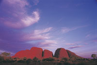
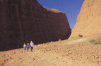
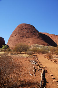
Estimated to be over 500 million years old, the 32
weathered rock domes that are Kata Tjuta sit 40 kilometres
to the west of Uluru/Ayers Rock. Kata Tjuta/The Olgas
represents nature on a monumental scale, with the clusters
tallest peak being 200m higher than Uluru!
http://www.environment.gov.au/parks/uluru/
|
 |
|
|
|
|
Much like its geological cousin, Kata Tjuta is most
spectacular when viewed at sunrise or sunset. If youre
after some serious adventure, you can grasp how incredibly
ancient and remarkably imposing Kata Tjuta is by tackling
the moderately difficult Valley of the Winds Walk.
Trekkers are rewarded for their efforts with breathtaking
views over the desert plains of the Red Centre. Alternatively,
take the easier Walpa Gorge Walk for a more a leisurely
stroll amongst Kata Tjutas enormous domes into a lush
desert refuge for plants and wildlife.
Meaning many heads in the local Aboriginal tongue,
Kata Tjuta is deeply sacred to the Anangu people, who
have inhabited the area for more than 22,000 years.
Join a cultural tour to uncover some of Kata Tjutas
sacred mysteries.
Opening hours Uluru-Kata Tjuta National Park is open
all year round.
The park closes at night and opens:
2010 (Last update)
5.00 am - 9.00 pm during December, January, February
5.30 am - 8.30 pm during March
6.00 am - 8.00 pm during April
6.00 am - 7.30 pm during May
6.30 am - 7.30 pm during June, July
6.00 am - 7.30 pm during August
5.30 am - 7.30 pm during September
5.00 am - 8.00 pm during October
5.00 am - 8.00 pm during November
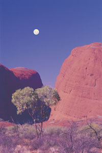
Valley of the Winds walk - Kata Tjuta
Open half an hour before sunrise - half an hour after
sunset.
The walk will be closed from the first
lookout (Karu) onwards: at 11am
if the temperature forecasted (at 4.30pm the day before)
is 36°C or above
if the actual temperature reaches 36°C or above during
rescue operations.
The Valley of the Winds Walk - Kata Tjuta
7.4 km full circuit | 3 hrs | commercial photography
not allowed The track to Karu (1st) Lookout, 1.1 km
from the carpark, is moderately difficult with some
loose rocks to negotiate so please mind your step and
wear sturdy footwear. The view is breathtaking and worth
the little bit of effort. This lookout is also the closure
point when the temperature reaches 36 degrees or greater.
The track to Karingana (2nd) Lookout, 2.7 km from carpark,
is challenging and very steep in places but also worthwhile.
The remainder of the Valley of the Winds Walk, 7.4 km
complete circuit, takes you down between the domes,
through creek beds and away from everyone and everything.
|
 |
|
|
|
|
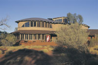
Cultural Centre
When you visit Uluru-Kata Tjuta National Park, you should
ensure that you explore the Cultural Centre first. You
will enjoy exploring the park much more if you understand
Anangu culture and this very special cultural and natural
environment.
Opening hours Cultural Centre
Open 7.00 am - 6.00 pm daily
Information Desk Open 8.00 am - 12 noon and 1.00 pm
- 5.00 pm daily
Entry to the Centre is free
Ininti Cafe and souvenirs
Provides a wide selection of souvenir gifts,
books, videos and clothing that feature Uluru and the
cultural heritage of its traditional owners. Ininti
Cafe has a comfortable air conditioned area for visitors
to sit down and enjoy light refreshments whilst enjoying
a magnificent view of Uluru.
Opening daily: 7:00 am - 5:15 pm
Phone (+61) 8 8956 2214
Fax (+61) 8 8956 2437
Email: ininticafeandsouvenirs@bigpond.com
or
Email: cafe@ininti.org.au
|
 |
 |
|
|
Talinguru Nyakunytjaku new viewing area
Talinguru Nyakunytjaku offers visitors stunning new
views of both Uluru and Kata Tjuta from a previously
inaccessible area of the park. The area allows visitors
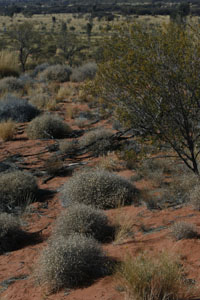
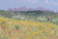
to see Uluru and Kata Tjuta in the wider desert landscape
of spinifex covered dunes and swales, dotted with kurkura
or desert oaks.
|
 |
|
|
Sunset and Sunrise maps and guide
Viewing areas Depending on where you are, whether it
is sunset or sunrise and what you are looking at, there
are many ways you can capture the beauty of this place
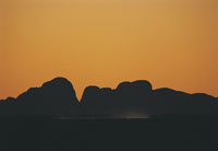
to remember your visit. Many people eagerly watch the
colour changes on the red rocks with the sun behind
them. Equally as stunning are the rocks as silhouettes,
especially if there are some clouds around this option
could also a good one if you want to escape the crowds.
A suggestion for when it rains is to head directly to
the base of Uluru and watch the waterfalls. Ask at the
entry station or Cultural Centre information for sunrise
and sunset times. Remember to stay on marked tracks
or behind the fences at all times.
1 Car Sunset Viewing views of Uluru
This is one of the most popular views of Uluru, especially
at sunset to watch the colour changes. For a silhouette
shot visit this area at sunrise. For those travelling
in cars, strictly no coaches.
2 Bus Sunset and Dune Walk Viewing
views of Uluru and Kata Tjuta Dune Walk lookout 500
metres return from carpark 30 mins This area is accessible
all day until 4pm, when it is set aside for the use
of buses and coaches. From this area you can see both
Uluru and Kata Tjuta. See the distinct vegetation of
dune habitats and tracks of birds and nocturnal animals.
Cars are not permitted in this area after 4pm: it is
for buses and coaches only, this is a safety precaution.
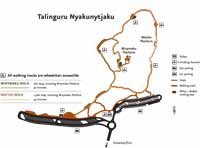
3 Talinguru Nyakunytjaku views of
Uluru and Kata Tjuta This destination captures both
Uluru and Kata Tjuta in the same shot and offers a stunning
360 degree view of the surrounding World Heritage landscape.
With no photography restrictions and the choice of three
wiljtas (shelters), two viewing platforms and a few
kilometres of walking track, you will be sure to find
a spot that suits your needs.
4 Kata Tjuta Dune Viewing area views
of Uluru and Kata Tjuta This provides a spectacular
panoramic view of Kata Tjuta with Uluru far away on
the right. Sun on the rocks at sunrise, silhouette at
sunset.
5 Kata Tjuta Sunset Viewing views
of Kata Tjuta Take a photo at sunset to see the stunning
colour change into the deepest red. Visitors are reminded
that they will need to be outside the Park boundary
one hour after sunset (the Park boundary is 45 minutes
drive from Kata Tjuta).
|
 |
 |
|
|
This is an area that provides different views throughout
the day, changing with the seasons. Here you begin to
understand the journeys of the creation ancestors and
the stories they left in the landscape.
Able to accomodate up to 3000 visitors, the area provides
several viewing platforms and a 1600 metre walking track
network, with spinifex thatched shade shelters modelled
on wiltja, the traditional Anangu shelter. There are
toilet facilities, solar powered wayfinder lighting,
a performance area and large capacity parking.
From the upper platforms of Talinguru Nyakunytjaku
it is possible to see out across open wanari or mulga
woodlands to patches of muurmuurpa or desert bloodwood
woodland fed by Uluru's rocky catchment. In Uluru's
clear light, you can often see landmarks more than 100
kilometres away, including the Musgrave Ranges in South
Australia.
The new road to the viewing area provides a wonderful
tourist drive through desert oak and mulga forest and
takes visitors through new areas of the landscape. Talinguru
Nyakunytjaku will create new business opportunities
for Aboriginal people and the tourism industry.
|
 |
 |
|
|
|
|
|
|
|
|
|
|
Find a self drive 4wd hire, camper,
motorhome or camper rental from Alice Springs
to Uluru and return or oneway to Darwin via
Kakadu and Litchfield.
See our specials at Australia
4wd Rentals or email
and ask us. Minimum rental is 5 days. Ask
us how to reserve a vehicle for only AUD $100
up to 9 months from travel.


|
|
|
Photographs Courtesy Of: NTTC
- Northern Territory Tourism Commission.
Maps Courtesy Of: NTTC - Northern Territory
Tourism Commission.
Photographs Courtesy Of: PJ B &
M Hutchinson Private Collections
Information courtesy of Parks and Wildlife Service NT
for the promotion of tourism for the Larapinta Trail.
Photographs
Courtesy of NTTC - Northern Territory
Tourism Commission
Information
courtesy of Parks Northern Territory
The Goholi
Our Mission Statement
As one of Australia's largest licensed
Travel Agents Goholi is dedicated to campervan and motorhome
hire and rentals. We will source the different options
for you. We will look at all the extras and find the
best vehicle package for you or even a multiple option
for you to choose from. With our head Office in the
heartland of the Top End of Darwin we can advise you
of the current situations of Uluru Kata Tjuta National
Park - Ayers Rock, Watarrka National Park, West MacDonnell
Ranges, East MacDonnell Ranges, Kakadu National Park,
Uluru (Ayers Rock), Gibb River Road Western Australia
and the - Erldunda - Kulgera - Oodnadatta Track - Coober
Pedy (Opal field) - Woomera - Port Augusta areas.
East MacDonnell National Park
and West MacDonnell National Park
in the MacDonnell Ranges in Northern Territory, Central
Australia
A tourist selfdrive tourist guide and travel information
East MacDonnell National Park
and West MacDonnell National Park in Central Australia
West
MacDonnell Map West
MacDonnell National Park East
MacDonnell National-Park
East
MacDonnell Map
West MacDonnell National Park
and surrounding areas
Larapinta
Trail Glen
Helen Gorge Glen
Helen Lodge accommodation Ellery
Creek Big Hole Ochre
Pits Ormiston
Gorge Redbank
Gorge Waterhole Roma
Gorge Serpentine
Chalet Serpentine
Gorge Simpsons
Gap Standley
Chasm
Honeymoon
Gap Palm
Valley
Albert
Namatjiras Monument
Namatjira
Drive Namatjira
Twin Gums Hermannsburg
Ghost
Gum Wallace
Rockhole Palm
Valley
East MacDonnell National Park
and surrounding areas
Arltunga
Historical Reserve and hotel or camping Trephina
Gorge Emily
Jessie Gap Corroboree
Rock Ross
River Resort Ruby
Gap N'Dhala
Gorge Nature Reserve Gemtree
Chambers
Pillar Rainbow
Valley
Other Highways, Scenic Routes,
Ways, offroad 4wd Tracks and Roads in Central Australia
The
Mereenie Loop Red
Centre Way Explorers
Way Stuart
Highway Ernest
Giles Road Namatjira
Drive Larapinta
Drive Luritja
Road Lasseter
Highway Binns
Track
Top End - Natures Way in Northern
Territory Australia
Darwin
Tropical
Darwin Map
of Northern Territory Katherine
Gorge Tennant
Creek Devils
Marbles Kakadu
National Park Natures
Way Top End Katherine
Gorge Litchfield
National Park
Alice Springs and Uluru and on
the way
Alice
Springs Alice
Springs Airport The
Ghan Alice Springs Alice
Springs Heavitree Gap Uluru
Kata Tjuta National Park
Uluru
Ayers Rock Ayers
Rock Resort at Yulara Voyages
Resort at Ayers Rock Resort, Yulara Ayers
Rock Airport 'Connellan Airport' Kata
Tjuta 'The Olgas' Sounds
of Silence dinner Mount
Sonder Mount
Connnor Mount
Ebenezer Curtin
Springs Stuarts
Well Erldunda
Kings Canyon
Watarrka
National Park Kings
Canyon Kings
Creek Station Kings
Canyon Resort Glen
Helen Lodge accommodation
Remote access sites
Henbury
Meteorites Conservation Reserve Gosse
Bluff Tnorala Tylers Pass Haasts
Bluff - lkuntji
Alice Springs camper hire and
Alice Springs motorhome rentals return and one way
Alice
Springs campervan hire and camper rentals
Alice Springs
motorhome hire and RV rentals
Alice Springs 4wd hire | Alice
Springs 4 wheel drive rentals | Alice Springs 4X4 hire
4WD Hire
from Alice Springs with oneways to Darwin
Uluru guided camping tours and
Kakadu guided camping safaris
Across Australia
Adventure Tours at http://www.australia4tours.com/
Uluru
Northern Territory www.uluruadventuretours.com
Kakadu
Northern Territory adventure tours and safaris at www.kakaduadventuretours.com
Way outback
Ayers Rock adventure tours and safaris at www.ulurusafaris.com
Way outback
Kakadu and Litchfield adventure tours and safaris at
www.kakadusafaris.com
Instant availability
on Kakadu and Top End one day tours www.kakaduholidays.com/
Instant
availability on Darwin one day tours www.darwin4tours.com/
Search, find and about West
MacDonnell National Park and East MacDonnell National
Park the MacDonnell Ranges in Central Australia a resource
travel guide.
|
|
|

